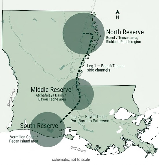
- North Reserve — Boeuf / Tensas area, Richland Parish region, near Meta Hyperion
- Middle Reserve — Atchafalaya Basin / Bayou Teche area
- South Reserve — Vermilion Coast / Pecan Island area, near SpaceX Starbase Louisiana
- Leg 1 — Boeuf/Tensas side channels (avoids Ouachita barge channel)
- Leg 2 — Bayou Teche, Port Barre to Patterson (~125 mi)
- Leg 1 — North to Middle. Down the Boeuf/Tensas side channels, oxbows, and sloughs from North Reserve to Middle Reserve.
- Leg 2 — Middle to South. Down Bayou Teche from the Atchafalaya Basin to the coast and South Reserve. Bayou Teche is Louisiana’s only National Water Trail, with 15 official docks.
Route-design note — Leg 1 and barge traffic. The Ouachita River main channel carries commercial barge traffic, so the thru-paddle route will be designed around it — using Boeuf/Tensas side channels, oxbows, and sloughs, with portages where needed. Exact routing, portages, and safety measures are to be confirmed in the feasibility study.
Passport loops or the thru-paddle
For most paddlers
The Tri-Reserve Passport
Curated 2–6 hour self-contained paddle loops at each reserve. Vehicle access at all hubs, with a digital GPS badge completion system. Most visitors will do one leg, one reserve, one day — and that is the point.
Expedition endurance route
The Louisiana Thru-Paddle
End-to-end expedition across the river systems, using dedicated backcountry platform camps, with a certified safety, portage, and GPS tracker network. A challenge for experienced paddlers — not the everyday experience.
Built for the water, honestly planned
Trail safety, portage points, campsites, and launch access are all part of the feasibility study — nothing on this page is a finished route yet. Planned features include up to 12 platform campsites and up to 85 miles of navigated trails across the corridor, with launch and vehicle access at each reserve hub.
Free public admission is a core part of the proposal: the reserves and their trails are meant to be open to everyone, not a private playground.